Geopolitical Zones of Nigeria
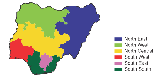
Geopolitical zoning of Nigeria is not a thing in the constitution of Nigeria. What we have are thirty-six (36) states and the federal capital territory, Abuja (Section 3 of the 1999 Nigerian Constitution). So how comes the term “Geopolitical Zones of Nigeria”?
The term/concept of geopolitical zoning of Nigeria was a suggestion in the second republic by the Vice President, Dr. Alex Ekwueme. The concept suggested that the Nigeria space is considered based on the sociocultural similarities which results into six (6) geopolitical zones. The seventh military head of state, Gen. Sani Abacha, did created states using the concept of six (6) geopolitical zones so to improve the balance among the regions in Nigeria. Although, the number of 36 states wasn’t shared evenly among the six (6) geopolitical zones as the South East region has five (5) states while the North West has seven (7); notwithstanding on the average the states were shared evenly.
The word “Nigeria” was chosen by Flora Shaw Baroness Lugard in an 1897 The Times publication to call the protectorates around the River Niger.
In 1906, the Lagos colony had been amalgamated with the Southern Protectorate to form a new Southern Nigerian Protectorate having Lagos as its capital.
The term was then used to name what became after the 1914 amalgamation of the Northern and Southern Nigerian Protectorates.
This, essentially, implied that after amalgamation, three regions had been joined to form one large unit. This was the case till the time of the Nigerian war.
During the Nigerian Civil war, twelve commands/states were created by Gen. Yakubu Gowon to reduce regional powers including that of the secessionist command/territory.
After the war, the second republic was ushered in. During this period, Dr. Alex Ekwueme, the Vice President of the country suggested the creation of six geopolitical zones to form the basis for power sharing so to foster equal resource allocation and unity.
After the times of Dr. Alex Ekwueme came a series of military leaderships which continued to create states to further reduce regional/state control. Gen. Sani Abacha, who happened to be the last military head of state to create states, did recognized the six (6) geopolitical zoning of Nigeria in the creation of the last six (6) states in 1996 so to balance the regional management of resources.
- North -West Zone: Jigawa, Kaduna, Kano, Katsina, Kebbi, Sokoto, Zamfara.
- North-East Zone: Adamawa, Bauchi, Borno, Gombe, Taraba, Yobe.
- North-Central Zone: Benue, Kogi, Kwara, Nasarawa, Niger, Plateau.
- South-West Zone: Ekiti, Lagos, Ogun, Ondo, Osun, Oyo.
- South-East Zone: Abia, Anambra, Ebonyi, Enugu, Imo.
- South-South Zone: Akwa Ibom, Bayelsa, Cross River, Delta, Edo, Rivers..
Since 1996, the geopolitical zoning of Nigeria has continued to be somewhat considered both in political parties for political appointments, rotational presidency, and in federal projects and development funds for resource allocation.
Also, there have been agitations for restructuring of the country to formally recognize the geopolitical zones as provinces in a parliamentary system of government wherein each province (i.e. geopolitical zone) would be in charge of her resources and pay taxes to the center, so to reduce the power at the center and increase resource control and cultural inclusion.
By recent developments, six (6) development commissions have been created for the six (6) geopolitical zones to foresee their development.
- Geopolitical zoning of Nigeria is a conventional concept that groups the Nigerian states into 6 similar sociocultural regions.
- The concept was suggested in the second republic by the then Vice President, Dr. Alex Ekwueme and later adopted by Gen. Sani Abacha in the creation of the last 6 states.
- The six (6) geopolitical zones are North-West, North-East, North-Central, South-West, South-East, and South-South.
- By recent development, six (6) development commissions have been created for the six (6) geopolitical zones to forsee their development.